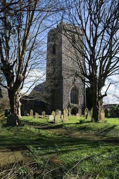
St Thomas’ Church
St. Thomas' Church, front view
Of all of the churches in and around Haverfordwest, St Thomas’ Church has the most fascinating history and most striking position.
For much of the town’s nine hundred year existence, it is the tower of St Thomas’ Church that has dominated the town.
The church has endured several rebuilds, the current building dating from 1855, but the tower is circa 15th century.
The origins are accepted as being around 1200 when the three churches situated in the town, St Mary’s, St Martin’s and St Thomas’, were gifted to the Priory as a means of income.
Two bells remain in the tower. The bigger of the two is inscribed, ‘Sanctus Gabriel; Ora pro Nobis.’ (Saint Gabriel; Pray for us); the smaller, on which are the words, ‘Thanks be to God’, is dated 1585.
For centuries the church had a close association with Haverfordwest Boys Grammar School thought to have originated in 1488 and which possibly used the tower for early classes.
The cemetery was used up until the nineteenth century as a ‘playground’ before the school relocated elsewhere in the town and eventually amalgamated with Taskers Girls Grammar School.
The seventeenth century provides a unique vignette into legend and tradition that allows a strong suggestion to have evolved of Charles II, whilst still a prince, marrying local girl Lucy Walter in this church. Proof is conveniently absent although Lucy was certainly one of the prince’s early romantic attachments and gave birth to a later claimant of the throne – James, who Charles recognised and ennobled as the Duke of Monmouth.
A cemetery incident in 1823 allows St Thomas’ to have the dubious honour of being the only church cemetery in Haverfordwest to have documented evidence of grave robbing, the deceased being John James and the suspected culprit Dr Brigstock, a medical trainee.
The church closed its doors in 2012.
At the point that the path takes a sharp left, descend instead the steps on your right, turn left at the bottom and continue down...
Base map from openstreetmap.org